|
In
1805, Gideon Fitz and John Dinsmore were engaged to make surveys in Washington
County, Alabama Territory. At that time
Washington County encompassed a large part of what is now southwestern
Alabama. Someone, perhaps one of those
surveyors, selected an initial point from which to begin the survey.[1] That point was located near the 31st
degree line north (if the line between Alabama and northern Florida were extended
westward it would be near that line) and on the west side of the Mobile river somewhere near the line between Mobile and Baldwin Counties. The meridian, later named the St. Stephens Meridian, ran north
and south from that point and the east west "base line" also ran from
that point. The meridian extends about
144 miles (24 tiers) northward from the initial point. Townships in the southern part of the state
were surveyed from there.
The
second meridian, used in the survey of the northern part of the state, is a
north-south line passing just west of downtown Huntsville and is called the
Huntsville Meridian. The "base
line" of the northern part of the state is from the Tennessee State
line. The Huntsville meridian survey
extends southward about 132 miles (22 tiers) to a line running from about
Sumter County eastward to Chambers County.
A "Township"
measures approximately six miles square on each side. Due
to convergence of meridians
and other factors, no township is exactly six miles square. Rows
of townships are surveyed east and west along the baseline and a row is called
a "tier." Tiers are numbered
north and south from the baseline. A
row of townships extending north and south is called a "Range." Ranges are numbered east and west from the
principal meridian. A township located
12 tiers south of the baseline and 14 ranges east of the principal meridian is
written "T12S, R14E." Ranges
are separated by "range lines", but the lines that separate tiers of
townships are not named. [2]
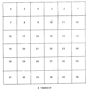
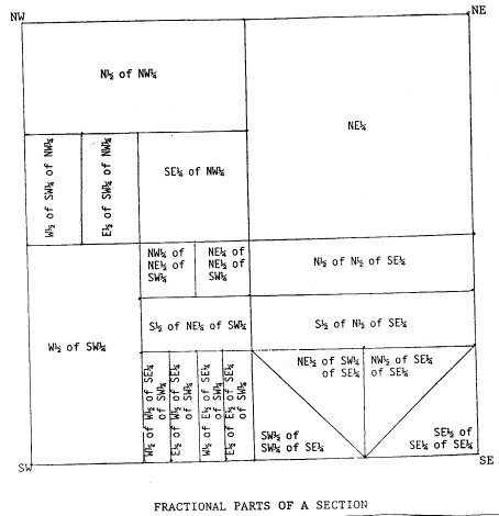
A
township contains 36 "Sections," each approximately one mile
square. Each section nominally contains
640 acres. Sections are usually divided
into quarter sections, which are then further divided into quarter quarters;
though they may be divided differently. Quarter sections are described as being the NE, NW, SE or SW
quarter. Quarter quarters are similarly
described. A quarter section is supposed
to contain 160 acres and a quarter quarter should contain 40 acres.
[3]
[4]
LOCATING A LAND SITE
Land
descriptions usually include the part of a section owned or granted in addition
to the township and range. One not
knowing approximately where a described land lies could consult the map in one
of Marilyn Davis Hahn's books on the various land offices in Alabama. The approximate site as shown in those books
can then be transferred to the index map for the topographic maps of
Alabama. Examining individual maps in
that area lets one find the township, range and sections described. My great grandfather, Eli Freeman, received a
grant in 1837 listed as NWNE S12 29-S 12-E HUNTSVILLE MERIDIAN, AL 3310_. 441.
(The northwest quarter of the northeast
quarter of Section 12 of Township 20 South and Range 12 East from the
Huntsville Meridian, Accession No. 3310-. 441.) Using the maps, one finds that it lies in Randolph County and is
land mapped in the Napoleon map. It is
on very steep land, so not very usable.
He acquired other land near that. The 1875 tax sale of property in
Randolph County listed part of his property as "ne se s six t twenty r
thirteen" (Northeast quarter of
the southeast quarter of section six, township twenty, range thirteen.
Since all land in Randolph County is south
and east of the Huntsville meridian, it was not necessary to specify that on
the sale listing.) I used an Alabama
Geological Survey topographic map to find this.
Topographic maps show roads and buildings as well as the
topography of the area.
|
|
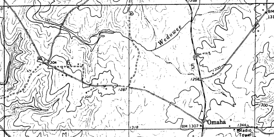 |
On this
map one can see that the described portion of Eli Freeman's property was 40
acres beginning half way between the 6 and the east border of Section 6, goes
to that eastern border, then extends southward 1/4 mile along the border to cross
the road between Omaha and Napoleon then westward 1/4 mile then back to the
starting point. One can tell whether
the land was flat enough to be farmed, see whether there was a stream or other
interesting feature and, since the map is fairly recent, also tell whether
there is a road that allows access to the property. The buildings shown may not be ones that were there in 1875, but
the topology will still be essentially as it was then.
Footnotes
[1] White,
Albert C., A History of the
Rectangular Survey System. Washington: U.S. Department of
the Interior, Bureau of Land Management, 1993. p. 56.
[2] Kissam,
Philip. Surveying for Civil
Engineers. New York: McGraw-Hill, 1981. p. 365.
[3] Hahn,
Marilyn Davis. Old St. Stephens'
Land Office Records and American State Papers Public Land, Vol. 1, 1768-1888. Easley, S.C.: Southern Historical Press,
1983. p. xxxviii.
|