
Graphic from |
| |
Contents |
History of the Public Land Survey System (PLSS)Information from Donovan Yingst's Early Federal Land Records, ESO, Bureau of Land Management The United States Public Land Survey System (PLSS) was enacted by Congress in the Land Ordinance of 1785 (reenacted in 1796) which established a Rectangular Survey System in the NW Territory . The ordinance required all Public Domain to be surveyed by the United States Government before title could be issued. First surveys of townships north of the Ohio River began in 1786 and the first land sale occurred in 1787; thereafter, land settlement on the frontier literally "boomed" as people moved westward. All states, except the Original Thirteen, Hawaii, Kentucky, Maine, Tennessee, Vermont, West Virginia and Texas are Public Domain States.
|
Bureau of Land Management (BLM)Information from Donovan Yingst's Early Federal Land Records, ESO, Bureau of Land Management TheEastern States Office of the Bureau of Land Management (ESO) has jurisdiction of public land records for the states of Alabama, Arkansas, Florida, Illinois, Indiana, Iowa, Louisiana, Michigan, Minnesota, Mississippi, Missouri, Ohio and Wisconsin. The BLM ESO maintains almost five million Federal land conveyance documents which precede and follow ratification of the constitution. The ESO began computerizing it's land records as part of the Bureau's General Land Office Automated Records Project in 1989 to preserve and protect them and make access easier for the public. Go to Eastern States Office of the Bureau of Land Management (ESO) for details about available land records. Eastern States Office
|
National Archives & Records Administration (NARA)Information from Donovan Yingst's Early Federal Land Records, ESO, Bureau of Land ManagementOnceland entry information is obtained from BLM, case materials may be ordered from the National Archives. Supply the following information in a request to the archives:
National Archives & Records Administration |
How the Public Land Survey System (PLSS) worksInformation partially from |
|
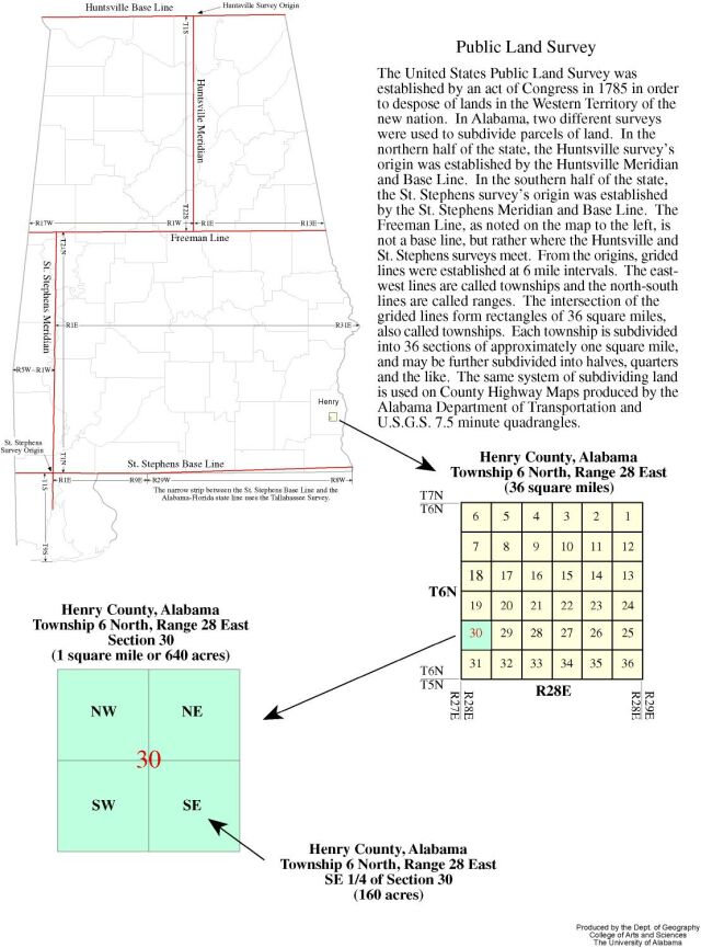 |
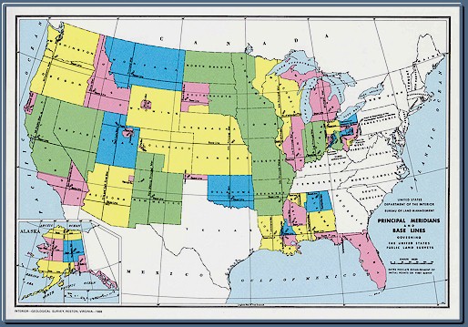
The following PLSS map of Alabama shows all townships.Graphic from Denis J. Dean, Ph.D. |
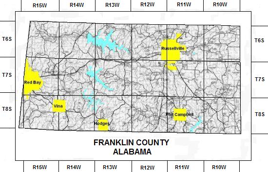
The following PLSS map of Franklin County shows Townships and Ranges.
|
The following Detail Maps by Township and Range shows individual sections.
|

T6S & R15W | T6S & R14W | T6S & R13W | T6S & R12W | T6S & R11W | T6S & R10W |
T7S & R15W | T7S & R14W | T7S & R13W | T7S & R12W | T7S & R11W | T7S & R10W |
T8S & R15W | T8S & R14W | T8S & R13W | T8S & R12W | T8S & R11W | T8S & R10W |
American State PapersInformation from Donovan Yingst's Genealogical Riches in the American State Papers. TheAMERICAN STATE PAPERS (PAPERS) is a collection of documents that preserves executive and legislative writings from the archives and manuscript records of the Senate and House. The original 38 volumes were published by Gales and Seaton 1832-61 under authority of Congress. Southern Historical Press, Inc. reprintedPAPERS, Vols. 1-9 andGRASSROOTS OF AMERICA (GRASSROOTS), a computerized index 1789-1837, in 1993. Volumes 1-8 of thePAPERScover various types of land claims onPublic Domain of the United States. Volume 9 pertains to claims against the government, usually not related to land. Nearly 80,000 diverse claims to land in early America (1789-1837) are treated generally giving genealogical/historical data such as: ages of claimants; previous places of habitation; names of children, wives, and other relatives; exact location of claims; and the time period of "cultivation and habitation". The Papers makes family data accessible that formerly was unavailable to many researchers. The PAPERS span an early period of American settlement and opens new opportunities in areas where data is often difficult to find. The data in these volumes, when combined with early land transactions in both the State Land and Public Domain States, furnishes a large reservoir of largely untapped family information. PAPERS often does not provide full family information, it furnishes stepping stones that lead to other research possibilities. The data, when combined with that in other sources, for instance, may demonstrate the movement of individuals and families successively from Colonial America to the West. Every family researcher with possible roots in early America should consult the PAPERS in the course of their investigations. Several excellent links to pages describing PAPERS now may be found online. A good place to start is: |
Land Records from the Bureau of Land Management
|
Resources
|